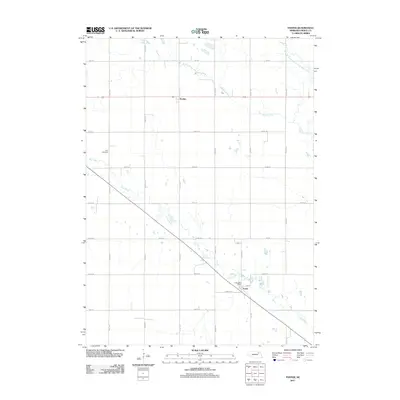
2011 Map of Foster
USGS Topo · Published 2011About this map
Foster and Breslau anchor this section of Pierce County, Nebraska, where the agricultural grid is intersected by the winding paths of Dry Creek and Breslau Creek. The settlement of Foster is particularly detailed, showing the Foster Post Office and a residential layout organized along 842nd Ave and local streets. To the northwest, the Zion Cemetery sits as a quiet landmark amidst the surrounding farmstead roads like 862nd Rd. The landscape is defined by its drainage towards the West Branch North Fork Elkhorn River in the northeast corner, reflecting the hydrological patterns that have shaped this prairie region. This survey captures the rural infrastructure of the early 21st century, from named section line roads to the enduring presence of small-town centers.
Find a feature on this map
17 named features on this map. Tap any name to fly to it.
Don’t see what you’re looking for? This feature index may not catch every label — zoom into the map to look around manually.
Map Details
Editions of this 2011 Foster Map
This is the sole edition of this map. No revisions or reprints were ever made.
Other maps of this area

1955 · Sioux City
USGS Topo · 1:250,000

1958 · Sioux City
USGS Topo · 1:250,000

1959 · Sioux City
USGS Topo · 1:250,000

1963 · Pierce NW
USGS Topo · 1:24,000

1963 · Plainview
USGS Topo · 1:24,000

1963 · Foster
USGS Topo · 1:24,000

1963 · Osmond
USGS Topo · 1:24,000
1963 · Tilden NE
USGS Topo · 1:24,000
1963 · Pierce
USGS Topo · 1:24,000

1971 · Wausa
USGS Topo · 1:24,000