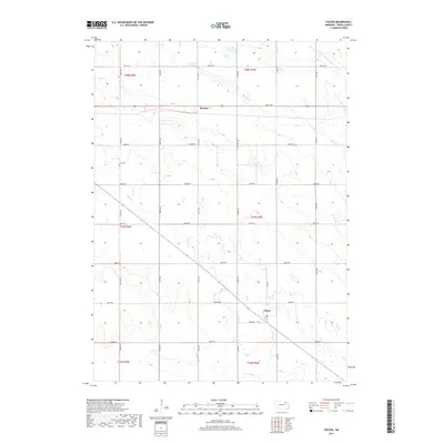
2017 Map of Foster
USGS Topo · Published 2017About this map
The unincorporated community of Foster and the settlement of Breslau anchor this section of Pierce County, Nebraska. This agricultural landscape is defined by the section line roads that create a rhythmic grid across the undulating terrain. Waterways like the W Br North Fork Elkhorn River and Breslau Cr wind through the northern sections, while Dry Cr cuts across the central and southern portions of the map. These drainage patterns influenced the placement of the early road network, which includes routes such as 864th Rd and 541st Ave. Local history is anchored by the Zion Cem, a quiet landmark among the fields. The survey captures the enduring rural character of this High Plains region, where the economy remains tied to the land and its network of small, scattered hubs.
Find a feature on this map
27 named features on this map. Tap any name to fly to it.
Don’t see what you’re looking for? This feature index may not catch every label — zoom into the map to look around manually.
Map Details
Editions of this 2017 Foster Map
This is the sole edition of this map. No revisions or reprints were ever made.
Other maps of this area

1955 · Sioux City
USGS Topo · 1:250,000

1958 · Sioux City
USGS Topo · 1:250,000

1959 · Sioux City
USGS Topo · 1:250,000

1963 · Pierce NW
USGS Topo · 1:24,000

1963 · Plainview
USGS Topo · 1:24,000

1963 · Foster
USGS Topo · 1:24,000

1963 · Osmond
USGS Topo · 1:24,000
1963 · Tilden NE
USGS Topo · 1:24,000
1963 · Pierce
USGS Topo · 1:24,000

1971 · Wausa
USGS Topo · 1:24,000