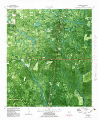
1982 Map of Fountain
USGS Topo · Published 1983About this map
Fountain and the northern edge of Youngstown anchor this 1980s orthophotomap of the Florida Panhandle, where the landscape is defined by the dense, branching drainage basins of the Bear Creek system. The Atlanta and Saint Andrews Bay railroad cuts a straight north-south line through the terrain, paralleling the main roadway and serving as a primary corridor for this rural timber and agricultural region. Higher ground is found at Mitchell Hill, while the lower reaches are dominated by complex watercourses like Juniper Creek, Pine Oak Creek, and Little Moccasin Cr. This map provides a clear view of the intersection of industrial infrastructure and natural hydrology, featuring a prominent Lookout Tower, multiple Cemeteries, and a Pipeline that traverses the wooded areas between Washington and Bay Counties.
Find a feature on this map
21 named features on this map. Tap any name to fly to it.
Don’t see what you’re looking for? This feature index may not catch every label — zoom into the map to look around manually.
Map Details
Editions of this 1982 Fountain Map
This is the sole edition of this map. No revisions or reprints were ever made.
Other maps of this area

1944 · Bayhead
USGS Topo · 1:24,000

1944 · Bennett
USGS Topo · 1:24,000

1945 · Juniper Creek
USGS Topo · 1:31,680

1945 · Youngstown
USGS Topo · 1:31,680

1945 · Bennett
USGS Topo · 1:31,680

1945 · Bayhead
USGS Topo · 1:31,680

1945 · Broad Branch
USGS Topo · 1:31,680

1945 · Fountain
USGS Topo · 1:31,680

1950 · Gap Lake
USGS Topo · 1:24,000

1951 · Gap Pond
USGS Topo · 1:24,000