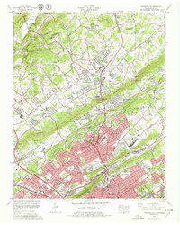
1978 Map of Fountain City
USGS Topo · Published 1979About this map
Fountain City and Halls Crossroads serve as the primary residential and commercial anchors for this Knoxville-area landscape, where the ridges of Copper Ridge and Blackoak Ridge dictate the flow of expansion. The Tennessee Valley Authority's influence is evident in the detailed mapping of the sprawling northern suburbs, showing a dense network of family institutions like Emory Valley Church and Sterchi Sch. The transition from rural valley floors to organized residential tracts is visible in the emergence of Bonta Vista Estates and Hallbrook alongside older landmarks such as Lynnhurst Cem.
Find a feature on this map
149 named features on this map. Tap any name to fly to it.
Don’t see what you’re looking for? This feature index may not catch every label — zoom into the map to look around manually.
Map Details
Editions of this 1978 Fountain City Map
2 editions found
Other maps of this area

1886 · Knoxville
USGS Topo · 1:125,000

1892 · Knoxville
USGS Topo · 1:125,000

1893 · Briceville
USGS Topo · 1:125,000

1894 · Knoxville
USGS Topo · 1:125,000

1895 · Loudon
USGS Topo · 1:125,000

1895 · Briceville
USGS Topo · 1:125,000

1895 · Knoxville
USGS Topo · 1:125,000

1896 · Briceville
USGS Topo · 1:125,000

1897 · Maynardville
USGS Topo · 1:125,000

1900 · Maynardville
USGS Topo · 1:125,000