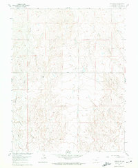
1961 Map of Fountain NE
USGS Topo · Published 1974About this map
Williams Creek and Chico Creek define the drainage patterns of this high plains landscape southeast of Colorado Springs during the early 1960s. The map illustrates a transitional rural environment where traditional cattle ranching footprints, such as Kane Ranch and the Bailey Windmill, exist alongside emerging infrastructure. The presence of a long Pipeline and the industrial activity at a Gravel Pit indicate the shifting utility of the land during this period. Navigation across the eastern El Paso County terrain is centered on Squirrel Creek Road, which serves as a primary east-west corridor through the undulating ranchlands. This survey is particularly useful for genealogists and local historians tracing the physical evolution of specific family-held tracts and early water management features in the Fountain area before later-century suburban development reached this sector.
Find a feature on this map
7 named features on this map. Tap any name to fly to it.
Don’t see what you’re looking for? This feature index may not catch every label — zoom into the map to look around manually.
Map Details
Editions of this 1961 Fountain NE Map
2 editions found
Other maps of this area

1893 · Big Springs
USGS Topo · 1:125,000

1893 · Colorado Springs
USGS Topo · 1:125,000

1909 · Colorado Springs
USGS Topo · 1:125,000

1942 · Colorado Springs
USGS Topo · 1:125,000

1948 · Fountain SE
USGS Topo · 1:24,000

1948 · Fountain
USGS Topo · 1:24,000

1948 · Falcon
USGS Topo · 1:62,500
1949 · Buttes
USGS Topo · 1:24,000

1949 · Corral Bluffs
USGS Topo · 1:24,000
1950 · Elsmere
USGS Topo · 1:24,000