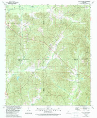
1989 Map of Four Corners
USGS Topo · Published 1989About this map
Four Corners sits at the intersection of Attala, Winston, Neshoba, and Leake counties, marking a significant geographic meeting point in central Mississippi. This late-1980s landscape is defined by its rural density, where family-named landmarks and country churches like Bethlehem Ch and New Ebenezer Ch anchor the community history. The terrain is deeply carved by water systems such as Bibalucia Creek and Labutcha Creek, while higher elevations like the Smallwood Hills provide vantage points once utilized by the Mars Hill Lookout. Scattered settlements like Zama and Alice are connected by a network of unimproved roads and light-duty paths, reflecting a traditional southern rural development pattern. Researchers can find numerous small burial grounds, including Kelley Cem and Shields Cem, which offer essential clues for tracing local genealogy within this multi-county borderland.
Find a feature on this map
35 named features on this map. Tap any name to fly to it.
Don’t see what you’re looking for? This feature index may not catch every label — zoom into the map to look around manually.
Map Details
Editions of this 1989 Four Corners Map
This is the sole edition of this map. No revisions or reprints were ever made.
Other maps of this area

1953 · Meridian
USGS Topo · 1:250,000

1953 · West Point
USGS Topo · 1:250,000

1957 · Meridian
USGS Topo · 1:250,000

1958 · West Point
USGS Topo · 1:250,000

1962 · Edinburg
USGS Topo · 1:62,500

1963 · West Point
USGS Topo · 1:250,000

1965 · Meridian
USGS Topo · 1:250,000

1972 · Pearl River
USGS Topo · 1:24,000

1972 · Plattsburg
USGS Topo · 1:24,000
1972 · Ethel SE
USGS Topo · 1:24,000