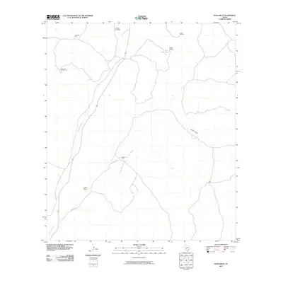
2010 Map of Four Mills
USGS Topo · Published 2010About this map
Dry Devils River and the ephemeral drainage of Buffalo Draw define the topography of this Val Verde County landscape. The area is characterized by isolated cattle operations and water management infrastructure, including Rock Barn Tank and several named wells such as Windmill Number One and Buffalo Windmill. These features indicate the critical nature of water access in the arid Edwards Plateau region.
Find a feature on this map
13 named features on this map. Tap any name to fly to it.
Don’t see what you’re looking for? This feature index may not catch every label — zoom into the map to look around manually.
Map Details
Editions of this 2010 Four Mills Map
This is the sole edition of this map. No revisions or reprints were ever made.
Other maps of this area

1943 · Carta Valley
USGS Topo · 1:62,500

1944 · Dry Devil
USGS Topo · 1:62,500

1954 · Sonora
USGS Topo · 1:250,000

1958 · Sonora
USGS Topo · 1:250,000

1958 · Del Rio
USGS Topo · 1:250,000

1964 · Del Rio
USGS Topo · 1:250,000

1971 · Turney Draw SE
USGS Topo · 1:24,000
1971 · Turney Draw NE
USGS Topo · 1:24,000
1971 · Carta Valley NE
USGS Topo · 1:24,000

1973 · Turney Draw NW
USGS Topo · 1:24,000