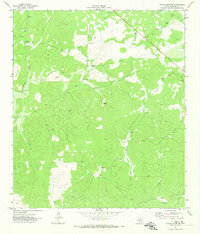
1971 Map of Turney Draw NE
USGS Topo · Published 1974About this map
Isolated family outposts like the Paul Turney Ranch and Mayfield Ranch define the settlement pattern of this Edwards County landscape in the early 1970s. The topography is dominated by the winding course of the Dry Devils River and its tributary systems, including Big Turney Draw and Wheat Draw. This survey captures a rural Texas ranching economy where property access and water management are paramount, as seen in the numerous Gravel Pits and scattered Drill Holes that dot the terrain. Subterranean features like Turney Cave and Wheel Cave reflect the area's karst geology, while an isolated Landing Strip suggests the necessity of air travel for reaching these distant homesteads. Local history is etched into the land through family-named features like the Jack Turney Ranch and Adamson Ranch, providing a clear record of land ownership and use during this era of Texas Water Development Board oversight.
Find a feature on this map
20 named features on this map. Tap any name to fly to it.
Don’t see what you’re looking for? This feature index may not catch every label — zoom into the map to look around manually.
Map Details
Editions of this 1971 Turney Draw NE Map
This is the sole edition of this map. No revisions or reprints were ever made.
Other maps of this area

1893 · Rock Springs
USGS Topo · 1:125,000

1954 · Sonora
USGS Topo · 1:250,000

1958 · Sonora
USGS Topo · 1:250,000

1963 · Harrison Ranch
USGS Topo · 1:24,000

1967 · Dunbar Draw SW
USGS Topo · 1:24,000

1967 · Dunbar Draw SE
USGS Topo · 1:24,000

1970 · Ray Lake NW
USGS Topo · 1:24,000

1971 · Turney Draw SE
USGS Topo · 1:24,000
1971 · Ray Lake SW
USGS Topo · 1:24,000

1973 · Turney Draw NW
USGS Topo · 1:24,000