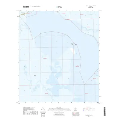
2020 Map of Fourleague Bay
USGS Topo · Published 2020About this map
Point Au Fer Island and the intricate coastal wetlands of Terrebonne Parish dominate this modern hydrographic study. The landscape is defined by a complex network of tidal channels and basins where Fourleague Bay meets the Gulf waters of Atchafalaya Bay. This map documents a fragile coastal environment characterized by numerous named passages such as Mosquito Pass and Little Mosquito Pass, which facilitate the movement of water through the salt marshes. The nomenclature reflects a long history of local navigation and wildlife, seen in labels like Wildcat Bayou, Alligator Bayou, and Blue Hammock Bayou. Surveyed in the early twenty-first century, this record serves as a precise baseline for the shifting shoreline at Shell Point and the remote landmasses of Mosquito Island.
Find a feature on this map
25 named features on this map. Tap any name to fly to it.
Don’t see what you’re looking for? This feature index may not catch every label — zoom into the map to look around manually.
Map Details
Editions of this 2020 Fourleague Bay Map
This is the sole edition of this map. No revisions or reprints were ever made.
Other maps of this area

1932 · Lake Decade
USGS Topo · 1:62,500

1935 · Oyster Bayou
USGS Topo · 1:62,500

1945 · New Orleans
USGS Topo · 1:250,000

1957 · Lake Decade
USGS Topo · 1:62,500
1957 · Oyster Bayou
USGS Topo · 1:62,500

1957 · Point Au Fer
USGS Topo · 1:62,500

1963 · New Orleans
USGS Topo · 1:250,000

1966 · New Orleans
USGS Topo · 1:250,000
1970 · Point Au Fer NE
USGS Topo · 1:24,000
1970 · Point Au Fer
USGS Topo · 1:24,000