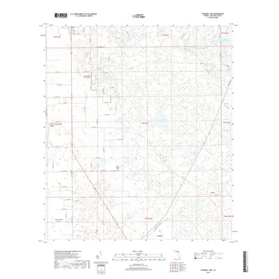
2018 Map of Fourmile Lake
USGS Topo · Published 2018About this map
Trenton and the surrounding Gilchrist County landscape are defined by a dense concentration of wetlands and karst ponds, forming a unique hydrologic network. The northern reaches include the community of Bell, while the southern area is anchored by the county seat. This terrain is characterized by features like the Waccasassa Flats and numerous small water bodies such as Mill Pond, Gator Pond, and the central Fourmile Lake. The agricultural and rural character of the era is evident through several private aviation landmarks, including the Flying Harness Farms Airport and the Watson Flight Strip. Local heritage is preserved at sites like Trenton Cem and Joppa Cem, providing essential points of reference for genealogists. The map also captures smaller, named localities like Tyler, situated amidst a grid of secondary roads and forest lands that illustrate the region's enduring rural layout.
Find a feature on this map
87 named features on this map. Tap any name to fly to it.
Don’t see what you’re looking for? This feature index may not catch every label — zoom into the map to look around manually.
Map Details
Editions of this 2018 Fourmile Lake Map
This is the sole edition of this map. No revisions or reprints were ever made.
Other maps of this area

1954 · Gainesville
USGS Topo · 1:250,000

1958 · Gainesville
USGS Topo · 1:250,000

1959 · Gainesville
USGS Topo · 1:250,000

1968 · Newberry SW
USGS Topo · 1:24,000

1968 · Waters Lake
USGS Topo · 1:24,000

1968 · Fourmile Lake
USGS Topo · 1:24,000

1968 · Hatchbend
USGS Topo · 1:24,000

1968 · Trenton
USGS Topo · 1:24,000
1968 · Suwannee River
USGS Topo · 1:24,000
1968 · Wannee
USGS Topo · 1:24,000