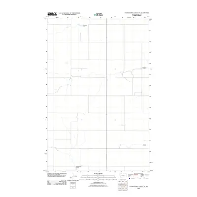
2011 Map of Fourteenmile Coulee NE
USGS Topo · Published 2011About this map
The northern plains of Hill County are defined here by a series of drainage features cutting through the Montana landscape. Water management and seasonal runoff dictate the character of this area, anchored by Narcissus Dam in the north and the deep-cut path of Fourteenmile Coulee at the southern boundary. The topography shows the subtle transition of the high prairie, where named draws like Faulkners Coulee and Halfway Coulee provide the primary relief in an otherwise expansive agricultural or grazing region. Apart from the established grid of section lines, Wolrey Sign Rd serves as a primary transit point through these coulees, reflecting the sparse, purposeful infrastructure typical of north-central Montana in the early 21st century.
Find a feature on this map
5 named features on this map. Tap any name to fly to it.
Don’t see what you’re looking for? This feature index may not catch every label — zoom into the map to look around manually.
Map Details
Editions of this 2011 Fourteenmile Coulee NE Map
This is the sole edition of this map. No revisions or reprints were ever made.
Other maps of this area

1904 · Boxelder
USGS Topo · 1:62,500

1906 · Kremlin
USGS Topo · 1:62,500

1906 · Boxelder
USGS Topo · 1:62,500

1919 · Big Sandy
USGS Topo · 1:125,000

1920 · Gildford
USGS Topo · 1:125,000

1943 · Gildford
USGS Topo · 1:125,000

1954 · Shelby
USGS Topo · 1:250,000

1958 · Shelby
USGS Topo · 1:250,000
1969 · Sage Lake
USGS Topo · 1:24,000

1969 · Box Elder NW
USGS Topo · 1:24,000