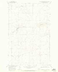
1969 Map of Fourteenmile Coulee NE
USGS Topo · Published 1972About this map
Faulkners Coulee and Fourteenmile Coulee carve through the high plains of Hill County in this late 1960s study of North-Central Montana. The landscape is characterized by its intermittent drainage systems and sparse settlement, typical of the Missouri River Basin development program era. Small signs of human activity are present at Van in the northeast and a lone Cem in the central-east, marking the quiet centers of local rural life. The presence of a designated Well and the winding course of Halfway Coulee illustrate the critical importance of water management in this arid stretch of the Great Plains. The map's contour lines reveal the intricate relief of the coulee systems as they descend through the terrain, providing a look at the topographical reality of Montana ranching country during this period.
Find a feature on this map
6 named features on this map. Tap any name to fly to it.
Don’t see what you’re looking for? This feature index may not catch every label — zoom into the map to look around manually.
Map Details
Editions of this 1969 Fourteenmile Coulee NE Map
This is the sole edition of this map. No revisions or reprints were ever made.
Other maps of this area

1904 · Boxelder
USGS Topo · 1:62,500

1906 · Kremlin
USGS Topo · 1:62,500

1906 · Boxelder
USGS Topo · 1:62,500

1919 · Big Sandy
USGS Topo · 1:125,000

1920 · Gildford
USGS Topo · 1:125,000

1943 · Gildford
USGS Topo · 1:125,000

1954 · Shelby
USGS Topo · 1:250,000

1958 · Shelby
USGS Topo · 1:250,000
1969 · Sage Lake
USGS Topo · 1:24,000

1969 · Box Elder NW
USGS Topo · 1:24,000