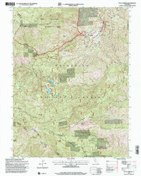
1996 Map of Fouts Springs
USGS Topo · Published 2001About this map
Mendocino National Forest defines the character of this mid-1990s survey, illustrating a landscape managed for both preservation and public use. The settlement at Fouts Springs and the nearby Fouts Camp serve as focal points for the area's recreational development, supported by infrastructure like the Landing Strip and the McDaniel Ranger Station. The topography is marked by significant glades, including Deafy Glade and Rattlesnake Glade, which break the dense drainage networks of Stony Creek and Sullivan Creek.
Find a feature on this map
57 named features on this map. Tap any name to fly to it.
Don’t see what you’re looking for? This feature index may not catch every label — zoom into the map to look around manually.
Map Details
Editions of this 1996 Fouts Springs Map
This is the sole edition of this map. No revisions or reprints were ever made.
Other maps of this area

1922 · Hullville
USGS Topo · 1:62,500

1924 · Bartlett Springs
USGS Topo · 1:62,500

1938 · Lakeport
USGS Topo · 1:62,500

1942 · Bartlett Springs
USGS Topo · 1:62,500

1944 · Bartlett Springs
USGS Topo · 1:62,500

1951 · Lake Pillsbury
USGS Topo · 1:62,500

1951 · Lakeport
USGS Topo · 1:62,500

1951 · Stonyford
USGS Topo · 1:62,500

1957 · Ukiah
USGS Topo · 1:250,000
1958 · Bartlett Mtn
USGS Topo · 1:24,000