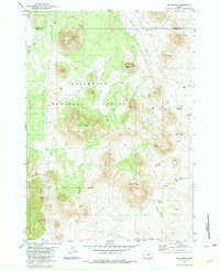
1981 Map of Fox Butte
USGS Topo · Published 1982About this map
Deschutes National Forest dominates this high-desert landscape on the boundary of Lake and Deschutes counties, where volcanic geology and range management define the terrain. The presence of Lava, The Blowouts, and the East Lava Field in the southern portion of the sheet points to the region's recent geological activity, anchored by the subterranean depth of Derrick Cave. Water management is central to the area's utility, evidenced by a network of isolated tanks and reservoirs such as Kittredge Reservoir, West Reservoir, and Squaw Butte Well. Evidence of human occupation is sparse, limited to functional landmarks like the Lookout Tower atop Fox Butte and the secluded Glen Cabin near the national forest boundary. The map is crossed by numerous 4wd tracks, illustrating the rugged infrastructure required to navigate between high points like Aspen Butte and the wide expanses of Watkins Flat.
Find a feature on this map
36 named features on this map. Tap any name to fly to it.
Don’t see what you’re looking for? This feature index may not catch every label — zoom into the map to look around manually.
Map Details
Editions of this 1981 Fox Butte Map
2 editions found
Other maps of this area

1955 · Crescent
USGS Topo · 1:250,000

1957 · Crescent
USGS Topo · 1:250,000

1958 · Crescent
USGS Topo · 1:250,000

1970 · Crescent
USGS Topo · 1:250,000

1981 · Fox Butte
USGS Topo · 1:24,000

1981 · Hogback Butte
USGS Topo · 1:24,000

1981 · Cougar Mtn
USGS Topo · 1:24,000
1981 · Plot Butte
USGS Topo · 1:24,000
1982 · Sixteen Butte
USGS Topo · 1:24,000
1982 · Firestone Butte
USGS Topo · 1:24,000