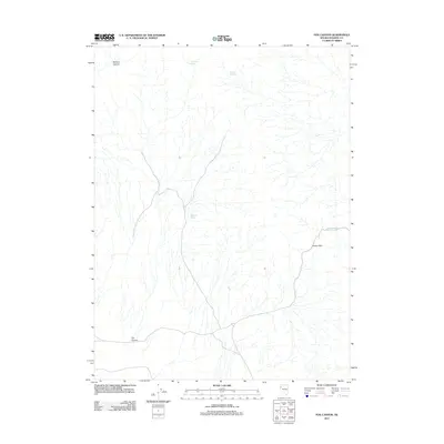
2011 Map of Fox Canyon
USGS Topo · Published 2011About this map
Fox Canyon and the surrounding high desert of Washoe County are defined by a network of seasonal water sources and topographic transitions. This 2011 survey documents a landscape where survival and movement are tied to specific reliable points like Fox Canyon Spring, Buckbrush Spring, and Summit Springs. The terrain is marked by significant drainages and elevations, notably Mullens Canyon in the northwest and the strategically named Sheep Pass to the east. These named springs and passes represent the primary landmarks in an otherwise open environment, tracing the historical routes used by wildlife and early travelers through the Great Basin. The concentration of water sources such as Sheep Pass Spring highlights the critical nature of these small hydrologic features in maintaining the local ecology and utility of the land.
Find a feature on this map
8 named features on this map. Tap any name to fly to it.
Don’t see what you’re looking for? This feature index may not catch every label — zoom into the map to look around manually.
Map Details
Editions of this 2011 Fox Canyon Map
This is the sole edition of this map. No revisions or reprints were ever made.
Other maps of this area

1886 · Granite Range
USGS Topo · 1:250,000

1894 · Granite Range
USGS Topo · 1:250,000

1955 · Lovelock
USGS Topo · 1:250,000

1959 · Lovelock
USGS Topo · 1:250,000

1964 · The Needle Rocks
USGS Topo · 1:24,000

1964 · Tohakum Peak NW
USGS Topo · 1:24,000

1964 · Kumiva Peak
USGS Topo · 1:62,500

1964 · Pyramid NE
USGS Topo · 1:24,000

1965 · Fox Range
USGS Topo · 1:62,500
1984 · Kumiva Peak
USGS Topo · 1:100,000