
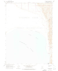
1964 Map of Pyramid NE
USGS Topo · Published 1966About this map
The eastern shores of Pyramid Lake define this high-desert landscape within the Pyramid Lake Indian Reservation. Along the water's edge, the wide arc of Fox Beach meets the waters of Fox Bay, providing a clear view of the shoreline as it existed in the mid-1960s. The terrain rises sharply to the east into a series of deeply etched drainages, most notably Sweetwater Canyon and the evocatively named Hells Kitchen Canyon.
Find a feature on this map
10 named features on this map. Tap any name to fly to it.
Don’t see what you’re looking for? This feature index may not catch every label — zoom into the map to look around manually.
Map Details
Editions of this 1964 Pyramid NE Map
2 editions found
Other maps of this area

1886 · Granite Range
USGS Topo · 1:250,000

1894 · Granite Range
USGS Topo · 1:250,000

1955 · Lovelock
USGS Topo · 1:250,000

1959 · Lovelock
USGS Topo · 1:250,000

1964 · The Needle Rocks
USGS Topo · 1:24,000
1964 · Dove Creek
USGS Topo · 1:24,000

1964 · Tohakum Peak NW
USGS Topo · 1:24,000
1964 · Pyramid SW
USGS Topo · 1:24,000

1964 · Kumiva Peak
USGS Topo · 1:62,500

1965 · Fox Range
USGS Topo · 1:62,500