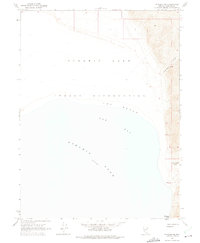
1964 Map of Pyramid NE
USGS Topo · Published 1975About this map
Pyramid Lake Indian Reservation dominates this shoreline survey, which captures the northeast reaches of the high-desert basin in the mid-1960s. The landscape is defined by the expansive waters of Pyramid Lake, where the shoreline transitions from the wide arc of Fox Beach and Fox Bay to the steep eastern escarpments. The interior terrain is marked by sharp elevation changes, notably at Howitzer Slide and through narrow geographic features like Hells Kitchen Canyon and Sweetwater Canyon. Sparse but vital water sources are documented, including Sweetwater Spring located at the head of its namesake canyon. This survey reveals a largely roadless environment where the topography itself dictated the movement of people and the limits of settlement within the reservation boundaries during this era.
Find a feature on this map
8 named features on this map. Tap any name to fly to it.
Don’t see what you’re looking for? This feature index may not catch every label — zoom into the map to look around manually.
Map Details
Editions of this 1964 Pyramid NE Map
2 editions found
Other maps of this area

1886 · Granite Range
USGS Topo · 1:250,000

1894 · Granite Range
USGS Topo · 1:250,000

1955 · Lovelock
USGS Topo · 1:250,000

1959 · Lovelock
USGS Topo · 1:250,000

1964 · The Needle Rocks
USGS Topo · 1:24,000
1964 · Dove Creek
USGS Topo · 1:24,000

1964 · Tohakum Peak NW
USGS Topo · 1:24,000
1964 · Pyramid SW
USGS Topo · 1:24,000

1964 · Kumiva Peak
USGS Topo · 1:62,500

1964 · Pyramid NE
USGS Topo · 1:24,000