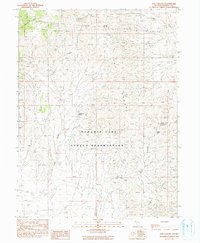
1990 Map of Fox Canyon
USGS Topo · Published 1990About this map
The Pyramid Lake Indian Reservation covers the southern half of this landscape, where the arid basin meets the steep elevation of the northern Nevada mountains. The terrain is defined by the high ridges of the Fox Range and the Lake Range, landforms that shaped the movement of people and livestock through these high-desert corridors. Water is the primary driver of development here, evidenced by the strategic locations of Fox Canyon Spring, Summit Springs, and Buckbrush Spring. These vital points, along with a solitary Trail winding through the northern canyons, mark the historic routes used for range management and travel across the Mullens Canyon and Fox Canyon drainages. The map reveals a remote environment where survival depended entirely on these scattered, named water sources.
Find a feature on this map
10 named features on this map. Tap any name to fly to it.
Don’t see what you’re looking for? This feature index may not catch every label — zoom into the map to look around manually.
Map Details
Editions of this 1990 Fox Canyon Map
This is the sole edition of this map. No revisions or reprints were ever made.
Other maps of this area

1886 · Granite Range
USGS Topo · 1:250,000

1894 · Granite Range
USGS Topo · 1:250,000

1955 · Lovelock
USGS Topo · 1:250,000

1959 · Lovelock
USGS Topo · 1:250,000

1964 · The Needle Rocks
USGS Topo · 1:24,000

1964 · Tohakum Peak NW
USGS Topo · 1:24,000

1964 · Kumiva Peak
USGS Topo · 1:62,500

1964 · Pyramid NE
USGS Topo · 1:24,000

1965 · Fox Range
USGS Topo · 1:62,500
1984 · Kumiva Peak
USGS Topo · 1:100,000