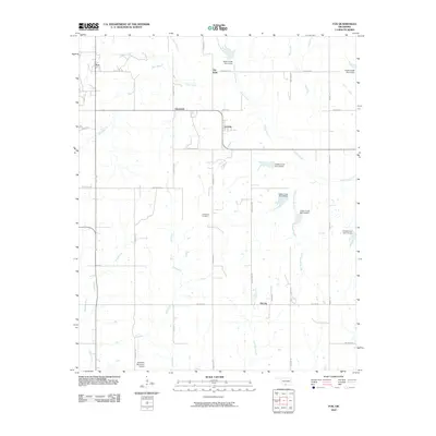
2010 Map of Fox
USGS Topo · Published 2010About this map
Oil City and Clemscott sit at the heart of this Southern Oklahoma landscape, where the legacy of the regional petroleum industry is reflected in both place names and infrastructure. The area is defined by a complex network of waterways, including Caddo Creek and several of its tributaries like Hug-me-tight Branch and Russell Pretty Branch. These streams are managed by a series of flood control structures, such as Caddo Creek Site 25 Dam and Caddo Creek Site 3 Dam.
Find a feature on this map
45 named features on this map. Tap any name to fly to it.
Don’t see what you’re looking for? This feature index may not catch every label — zoom into the map to look around manually.
Map Details
Editions of this 2010 Fox Map
This is the sole edition of this map. No revisions or reprints were ever made.
Other maps of this area

1901 · Addington
USGS Topo · 1:125,000

1901 · Ardmore
USGS Topo · 1:125,000

1918 · Ardmore
USGS Topo · 1:125,000

1957 · Ardmore
USGS Topo · 1:250,000

1963 · Ardmore
USGS Topo · 1:250,000

1968 · Fox NE
USGS Topo · 1:24,000

1969 · Healdton
USGS Topo · 1:24,000

1969 · Lone Grove
USGS Topo · 1:24,000
1969 · Milo
USGS Topo · 1:24,000
1969 · Tatums
USGS Topo · 1:24,000