
1969 Map of Lone Grove
USGS Topo · Published 1971About this map
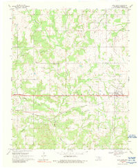
Lone Grove serves as the central hub of this late-1960s survey, situated along the Atchison Topeka and Santa Fe railroad line. The landscape reflects a mix of traditional agriculture and industrial development, dominated by an extensive Oil Field and supporting infrastructure like the Pumping Station and several Gravel Pits. Water resources are abundant throughout the quadrangle, with Walnut Bayou and Demijohn Creek carving through the southern terrain, while Cottonwood Creek and Red Branch drain the north. Local history is anchored by long-standing community landmarks, including the Blue Ribbon Ch, Lone Grove Cem, and Keller Cem. The map captures a moment of infrastructure growth, evidenced by a major highway noted as being under construction just west of the primary settlement, suggesting the area's increasing connectivity within Carter County.
Find a feature on this map
20 named features on this map. Tap any name to fly to it.
Don’t see what you’re looking for? This feature index may not catch every label — zoom into the map to look around manually.
Map Details
Editions of this 1969 Lone Grove Map
2 editions found
Other maps of this area

1901 · Ardmore
USGS Topo · 1:125,000

1918 · Ardmore
USGS Topo · 1:125,000

1957 · Ardmore
USGS Topo · 1:250,000

1963 · Ardmore
USGS Topo · 1:250,000

1964 · Ardmore West
USGS Topo · 1:24,000

1964 · Overbrook
USGS Topo · 1:24,000

1964 · Springer
USGS Topo · 1:24,000

1969 · Healdton
USGS Topo · 1:24,000
1969 · Healdton SW
USGS Topo · 1:24,000
1969 · Milo
USGS Topo · 1:24,000