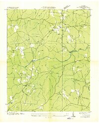
1936 Map of Fox Creek
USGS Topo · Published 1936About this map
The Cumberland Plateau in 1936 is characterized by a network of rural schools and small settlements connected by winding trails and river crossings. The Obed River carves through the center of the landscape, punctuated by Adams Bridge and Potter Ford, where early transit relied on these specific terrain-dictated points. Local life is anchored by dispersed educational and religious centers such as Shiloh Ch, Genesis Sch, and the Slate Springs Sch.
Find a feature on this map
66 named features on this map. Tap any name to fly to it.
Don’t see what you’re looking for? This feature index may not catch every label — zoom into the map to look around manually.
Map Details
Editions of this 1936 Fox Creek Map
This is the sole edition of this map. No revisions or reprints were ever made.
Other maps of this area

1887 · Kingston
USGS Topo · 1:125,000

1891 · Kingston
USGS Topo · 1:125,000

1892 · Pikeville
USGS Topo · 1:125,000

1893 · Kingston
USGS Topo · 1:125,000

1895 · Wartburg
USGS Topo · 1:125,000

1895 · Pikeville
USGS Topo · 1:125,000

1896 · Wartburg
USGS Topo · 1:125,000

1897 · Standingstone
USGS Topo · 1:125,000

1898 · Standingstone
USGS Topo · 1:125,000
1912 · Crossville
USGS Topo · 1:62,500