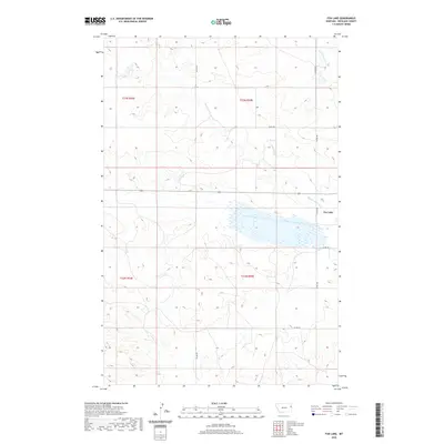
2020 Map of Fox Lake
USGS Topo · Published 2020About this map
Fox Lake dominates the central landscape of this Richland County region, serving as a primary hydrologic feature for the surrounding prairie. This 2020 edition documents the drainage network that feeds into this basin, specifically the Middle Fork Fox Cr and E Fork Fox Cr, which eventually consolidate into Fox Cr. The map details the modern section line road system that defines local transit, including north-south arteries like Co Rd 328 and Co Rd 324. This specific quadrangle covers portions of townships t23n r54e, t23n r55e, t22n r54e, and t22n r55e, illustrating the precise land divisions of eastern Montana. The interplay between the low-lying wetland of the lake and the surrounding elevations provides a clear view of the topography in this agricultural and ranching environment.
Find a feature on this map
13 named features on this map. Tap any name to fly to it.
Don’t see what you’re looking for? This feature index may not catch every label — zoom into the map to look around manually.
Map Details
Editions of this 2020 Fox Lake Map
This is the sole edition of this map. No revisions or reprints were ever made.
Other maps of this area

1909 · Glendive
USGS Topo · 1:250,000

1954 · Glendive
USGS Topo · 1:250,000

1957 · Glendive
USGS Topo · 1:250,000

1958 · Glendive
USGS Topo · 1:250,000

1972 · Butler Table
USGS Topo · 1:24,000

1972 · Fox Lake
USGS Topo · 1:24,000

1972 · Enid SE
USGS Topo · 1:24,000

1972 · Lambert
USGS Topo · 1:24,000
1972 · Mc Cone Heights
USGS Topo · 1:24,000

1972 · Enid
USGS Topo · 1:24,000