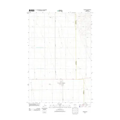
2013 Map of Foxhome
USGS Topo · Published 2013About this map
The settlement of Foxhome serves as the focal point of this western Minnesota landscape, situated at the junction of Mn-210 and Co HWY-19. The town's grid is clearly defined by local streets such as Broadway Ave and Heider St, and includes the local Po and the Foxhome Cem to the west. This area along the border of Wilkin Co and Otter Tail Co is defined by a sophisticated water management system, evident in the engineered paths of County Ditch Number Thirty One and County Ditch Number Three-Two. Beyond the town, the land is organized into a precise section-line road network, where genealogists can locate landmarks like Burau Cem in the northern reaches of the quadrangle. The map captures the agricultural regularity and drainage infrastructure essential to this region's rural economy.
Find a feature on this map
39 named features on this map. Tap any name to fly to it.
Don’t see what you’re looking for? This feature index may not catch every label — zoom into the map to look around manually.
Map Details
Editions of this 2013 Foxhome Map
This is the sole edition of this map. No revisions or reprints were ever made.
Other maps of this area

1910 · Wendell
USGS Topo · 1:62,500

1913 · Fergus Falls
USGS Topo · 1:62,500

1913 · Wendell
USGS Topo · 1:62,500

1919 · Rothsay
USGS Topo · 1:62,500

1951 · Rothsay
USGS Topo · 1:62,500

1951 · Campbell
USGS Topo · 1:62,500

1953 · Fargo
USGS Topo · 1:250,000

1956 · Fargo
USGS Topo · 1:250,000

1966 · Carlisle
USGS Topo · 1:24,000
1973 · Elizabeth
USGS Topo · 1:24,000