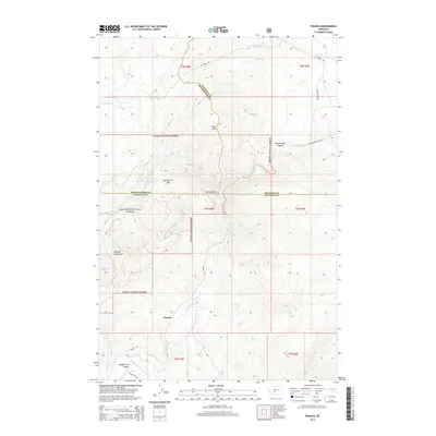
2014 Map of Francis
USGS Topo · Published 2014About this map
The settlement of Francis lies at a critical hydrological and jurisdictional juncture in the central Montana highlands. This area is defined by the steep transition from the Big Belt Mountains into the deep incisions of Sixteenmile Canyon and Middle Fork Canyon. Much of the territory is managed within the Helena National Forest, where the landscape is carved by the complex drainage systems of Sixteenmile Cr and its tributaries like Middle Fork Sixteenmile Cr and Paddys Run. High-elevation landmarks such as Wall Mtn and Sherlock Mtn overlook the winding courses of Sixteen Mile Rd and Francis Rd, which trace the narrow valley floors. The map also delineates the convergence of three county boundaries—Gallatin, Broadwater, and Meagher—near the confluence of Spring Gulch, marking a significant point of administrative intersection in this mountain terrain.
Find a feature on this map
27 named features on this map. Tap any name to fly to it.
Don’t see what you’re looking for? This feature index may not catch every label — zoom into the map to look around manually.
Map Details
Editions of this 2014 Francis Map
This is the sole edition of this map. No revisions or reprints were ever made.
Other maps of this area

1886 · Fort Logan
USGS Topo · 1:250,000

1886 · Little Belt Mts.
USGS Topo · 1:250,000

1894 · Little Belt Mts.
USGS Topo · 1:250,000

1897 · Little Belt Mts.
USGS Topo · 1:250,000

1898 · Little Belt Mts.
USGS Topo · 1:250,000

1902 · Little Belt Mts.
USGS Topo · 1:250,000

1948 · White Sulphur Springs
USGS Topo · 1:250,000

1948 · Sixteen
USGS Topo · 1:24,000

1949 · Maudlow
USGS Topo · 1:62,500
1951 · Hatfield Mountain
USGS Topo · 1:24,000