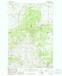
1986 Map of Francis
USGS Topo · Published 1986About this map
Sixteenmile Creek carves a deep path through the Montana highlands in the mid-1980s, marking a complex intersection of three counties. This landscape is defined by the high elevations of Wall Mountain and Sherlock Mountain, where the boundaries of the Helena National Forest and Gallatin National Forest meet. The settlement of Francis sits along the southern portion of the creek, serving as a rare point of habitation in a terrain otherwise characterized by steep drainages and mountain peaks. The map reveals the path of transportation history through the mountains, clearly tracing an Old Railroad Grade and a more recent Railroad Grade that follow the natural watercourse. These grades reflect the vital role of rail in navigating the difficult topography between Meagher, Broadwater, and Gallatin counties, providing a clear record of the infrastructure used to bypass these mountain barriers.
Find a feature on this map
17 named features on this map. Tap any name to fly to it.
Don’t see what you’re looking for? This feature index may not catch every label — zoom into the map to look around manually.
Map Details
Editions of this 1986 Francis Map
This is the sole edition of this map. No revisions or reprints were ever made.
Other maps of this area

1886 · Fort Logan
USGS Topo · 1:250,000

1886 · Little Belt Mts.
USGS Topo · 1:250,000

1894 · Little Belt Mts.
USGS Topo · 1:250,000

1897 · Little Belt Mts.
USGS Topo · 1:250,000

1898 · Little Belt Mts.
USGS Topo · 1:250,000

1902 · Little Belt Mts.
USGS Topo · 1:250,000

1948 · White Sulphur Springs
USGS Topo · 1:250,000

1948 · Sixteen
USGS Topo · 1:24,000

1949 · Maudlow
USGS Topo · 1:62,500
1951 · Hatfield Mountain
USGS Topo · 1:24,000