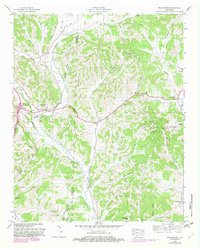
1948 Map of Frankewing
USGS Topo · Published 1982About this map
Frankewing serves as a focal point along the Louisville And Nashville railroad line, where the tracks parallel Bradshaw Creek through the rolling terrain of southern Tennessee. This mid-century landscape is defined by its deep hollows and prominent ridges, such as Backbone Ridge and Bustussle Hollow, which dictate the placement of small rural communities like McBurg and Taylortown. The map reveals a dense network of family history markers, including the Garrett, Swinebroad, and Hedgpeth cemeteries, alongside local landmarks like Lloyd Cave. Religious and social life is anchored by country churches including Young Chapel and Bee Spring Ch, illustrating the traditional settlement patterns that persisted in Giles and Lincoln counties through the 1940s. The alignment of Old Highway 15 further demonstrates the transition of regional transportation from rail-dependent commerce to early highway travel.
Find a feature on this map
65 named features on this map. Tap any name to fly to it.
Don’t see what you’re looking for? This feature index may not catch every label — zoom into the map to look around manually.
Map Details
Editions of this 1948 Frankewing Map
2 editions found
Other maps of this area

1936 · Cornersville
USGS Topo · 1:24,000

1936 · Taft
USGS Topo · 1:24,000

1936 · Boonshill
USGS Topo · 1:24,000

1936 · Brick Church
USGS Topo · 1:24,000

1936 · Petersburg
USGS Topo · 1:24,000

1936 · Tarpley
USGS Topo · 1:24,000

1936 · Elkton
USGS Topo · 1:24,000

1936 · Frankewing
USGS Topo · 1:24,000

1936 · Dellrose
USGS Topo · 1:24,000

1944 · Shelbyville
USGS Topo · 1:100,000