
1976 Map of Frankfort SW
USGS Topo · Published 1976About this map
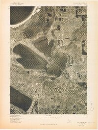
Lake Michigan dominates the western edge of this 1976 orthophotograph, where the deep-water harbor at Elberta meets the coastline. This aerial-based survey provides a precise visual record of the shoreline and inland topography before modern development patterns shifted, focusing on the interface between the lake and the sheltered waters of Betsie Lake. The settlement of Watervale further south reflects the quiet, forested character of the Benzie County coast during the mid-1970s. For researchers, the photographic nature of this advance print offers a distinct advantage over traditional line maps, revealing the exact tree lines, field boundaries, and road structures as they existed on the ground. It serves as a clear document of the land use patterns and rural layout of the region during a period of relative stability in northern Michigan's coastal communities.
Find a feature on this map
4 named features on this map. Tap any name to fly to it.
Don’t see what you’re looking for? This feature index may not catch every label — zoom into the map to look around manually.
Map Details
Editions of this 1976 Frankfort SW Map
This is the sole edition of this map. No revisions or reprints were ever made.
Other maps of this area

1954 · Manitowoc
USGS Topo · 1:250,000

1956 · Onekama
USGS Topo · 1:62,500

1956 · Bar Lake
USGS Topo · 1:62,500

1956 · Frankfort
USGS Topo · 1:62,500

1958 · Manitowoc
USGS Topo · 1:250,000

1976 · Frankfort SE
USGS Topo · 1:24,000

1976 · Frankfort NW
USGS Topo · 1:24,000

1976 · Onekama NW
USGS Topo · 1:24,000
1976 · Frankfort NE
USGS Topo · 1:24,000
1976 · Onekama NE
USGS Topo · 1:24,000