1969 Map of Franklin
USGS Topo · Published 1973About this map
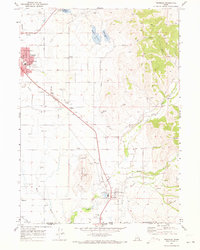
The Union Pacific Railroad cuts a diagonal path through this 1960s agricultural landscape, connecting the Idaho settlements of Preston, Whitney, and Franklin. The map reveals a highly developed irrigation system critical to the region's farming economy, featuring the Upper Canal, Lower Canal, and East Canal alongside natural waterways like the Cub River and Worm Creek. Significant civic infrastructure is documented in the northern hub of Preston, where the Hospital, Armory, and Highway Maint Sta sit near multiple schools.
Find a feature on this map
48 named features on this map. Tap any name to fly to it.
Don’t see what you’re looking for? This feature index may not catch every label — zoom into the map to look around manually.
Map Details
Editions of this 1969 Franklin Map
This is the sole edition of this map. No revisions or reprints were ever made.
Other maps of this area

1914 · Logan
USGS Topo · 1:125,000

1915 · Preston
USGS Topo · 1:96,000

1916 · Logan
USGS Topo · 1:125,000

1918 · Preston
USGS Topo · 1:125,000

1954 · Ogden
USGS Topo · 1:250,000

1955 · Preston
USGS Topo · 1:250,000

1958 · Ogden
USGS Topo · 1:250,000

1958 · Preston
USGS Topo · 1:250,000

1960 · Ogden
USGS Topo · 1:250,000

1962 · Preston
USGS Topo · 1:250,000