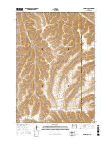
2017 Map of Franklin Hill
USGS Topo · Published 2017About this map
Franklin Hill rises above a deeply carved landscape in this high-altitude section of Eastern Oregon where the Morrow Co Umatilla Co border line bisects the high desert terrain. The drainage patterns here are complex, defined by a network of steep-sided draws including Buttermilk Canyon and Cunningham Canyon that feed toward the northeast. In the southern portion of the quadrangle, family-named landmarks like Cunha Canyon and Matlock Canyon sit near the winding course of Huges-Hirl Rd. The presence of Dry Hog Hollow Dixie Canyon and Hog Hollow suggests a rugged history of livestock grazing and water management in an area where Butter Cr provides one of the few named water sources in the upper reaches of the plateau.
Find a feature on this map
15 named features on this map. Tap any name to fly to it.
Don’t see what you’re looking for? This feature index may not catch every label — zoom into the map to look around manually.
Map Details
Editions of this 2017 Franklin Hill Map
This is the sole edition of this map. No revisions or reprints were ever made.
Other maps of this area

1908 · Umatilla
USGS Topo · 1:125,000

1953 · Pendleton
USGS Topo · 1:250,000

1956 · Pendleton
USGS Topo · 1:250,000

1967 · Freezeout Ridge
USGS Topo · 1:24,000

1968 · Hoodlum Canyon
USGS Topo · 1:24,000
1968 · Echo SE
USGS Topo · 1:24,000

1968 · Lena
USGS Topo · 1:24,000

1968 · Vey Ranch
USGS Topo · 1:24,000

1968 · Gurdane
USGS Topo · 1:24,000
1968 · Vinson
USGS Topo · 1:24,000