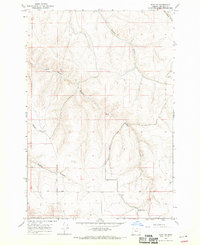
1968 Map of Echo SE
USGS Topo · Published 1970About this map
Alkali School stands as a focal point of this rural Umatilla County landscape, which is defined by a series of deep drainages cutting through the high plateau. The topography is dominated by the winding paths of Mud Spring Canyon, Alkali Canyon, and Speare Canyon, which create a complex network of ridges and draws. This late 1960s survey illustrates a region largely focused on land management and natural resources, evidenced by the prominent Base Line survey marker and several Gravel Pit sites. Transportation is limited to a few light-duty roads and a network of Jeep Trails that navigate the terrain between landmarks like Slusher Canyon and Spikes Gulch. The map provides a clear picture of the vast, open spaces of eastern Oregon before significant modern development, emphasizing the relationship between the seasonal water sources and the local topography.
Find a feature on this map
14 named features on this map. Tap any name to fly to it.
Don’t see what you’re looking for? This feature index may not catch every label — zoom into the map to look around manually.
Map Details
Editions of this 1968 Echo SE Map
2 editions found
Other maps of this area

1908 · Umatilla
USGS Topo · 1:125,000

1935 · Pendleton
USGS Topo · 1:125,000

1953 · Pendleton
USGS Topo · 1:250,000

1956 · Pendleton
USGS Topo · 1:250,000
1966 · Barnhart
USGS Topo · 1:24,000
1966 · Coombs Canyon
USGS Topo · 1:24,000

1967 · Nye
USGS Topo · 1:24,000
1968 · Echo
USGS Topo · 1:24,000
1968 · Nolin
USGS Topo · 1:24,000
1968 · Vinson
USGS Topo · 1:24,000