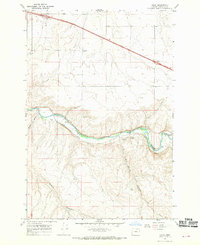
1968 Map of Nolin
USGS Topo · Published 1970About this map
Nolin and Yoakum sit along a sharp bend of the Umatilla River in this late 1960s Umatilla County survey. The landscape is defined by the heavy infrastructure of the Union Pacific railroad, which follows the river's winding course through the valley, notably navigating the dramatic Horseshoe Curve. To the north, the modern footprint of Interstate 80n is visible, including the Echo Interchange and Rew Interchange, marking a transition in regional transportation.
Find a feature on this map
21 named features on this map. Tap any name to fly to it.
Don’t see what you’re looking for? This feature index may not catch every label — zoom into the map to look around manually.
Map Details
Editions of this 1968 Nolin Map
This is the sole edition of this map. No revisions or reprints were ever made.
Other maps of this area

1908 · Umatilla
USGS Topo · 1:125,000

1935 · Pendleton
USGS Topo · 1:125,000

1953 · Pendleton
USGS Topo · 1:250,000

1956 · Pendleton
USGS Topo · 1:250,000

1962 · Stanfield
USGS Topo · 1:24,000

1962 · Stanfield SE
USGS Topo · 1:24,000

1966 · Holdman
USGS Topo · 1:24,000
1966 · Barnhart
USGS Topo · 1:24,000
1966 · Coombs Canyon
USGS Topo · 1:24,000
1968 · Echo SE
USGS Topo · 1:24,000