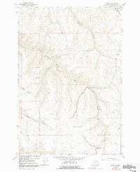
1968 Map of Echo SE
USGS Topo · Published 1991About this map
The dry, dissected canyons of Umatilla County are frozen in time on this mid-century survey of the high desert terrain. Alkali Canyon serves as a primary geographical axis, flanked by the Alkali School and several agricultural or extraction sites. The landscape is defined by its deep drainage patterns, including Speare Canyon and Slusher Canyon, which cut through the plateaus toward the Base Line in the southern portion of the quadrangle. The map documents the scattered industrial and rural infrastructure of the era, from a Gravel Pit near the eastern margin to a Grave Pit located further south. This record captures the region's character through its specific local nomenclature, where named features like Spikes Gulch and Mud Spring Canyon indicate the essential role of water and topography in early 20th-century land use and settlement.
Find a feature on this map
10 named features on this map. Tap any name to fly to it.
Don’t see what you’re looking for? This feature index may not catch every label — zoom into the map to look around manually.
Map Details
Editions of this 1968 Echo SE Map
2 editions found
Other maps of this area

1908 · Umatilla
USGS Topo · 1:125,000

1935 · Pendleton
USGS Topo · 1:125,000

1953 · Pendleton
USGS Topo · 1:250,000

1956 · Pendleton
USGS Topo · 1:250,000
1966 · Barnhart
USGS Topo · 1:24,000
1966 · Coombs Canyon
USGS Topo · 1:24,000

1967 · Nye
USGS Topo · 1:24,000
1968 · Echo SE
USGS Topo · 1:24,000
1968 · Echo
USGS Topo · 1:24,000
1968 · Nolin
USGS Topo · 1:24,000