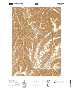
2020 Map of Franklin Hill
USGS Topo · Published 2020About this map
Franklin Hill rises as a prominent landmark in this corner of Umatilla County, marking a landscape defined by an intricate network of drainages and upland ridges. The terrain is deeply incised by named geographic features such as Matlock Canyon, Cunha Canyon, and the curiously named Dry Hog Hollow. To the northeast, the waters of Butter Cr flow through the territory, paralleled by the primary thoroughfare of Butter Creek Rd. This modern survey illustrates the persistent rural character of the region along the boundary between Morrow and Umatilla Counties. Transportation across these heights relies on established routes like Huges-Hirl Rd and Hisler Rd, which navigate the various gaps and basins including Buttermilk Canyon, Cunningham Canyon, and Nelson Canyon. The map provides a precise view of the topography and land management divisions of this high-plateau environment in the early twenty-first century.
Find a feature on this map
18 named features on this map. Tap any name to fly to it.
Don’t see what you’re looking for? This feature index may not catch every label — zoom into the map to look around manually.
Map Details
Editions of this 2020 Franklin Hill Map
This is the sole edition of this map. No revisions or reprints were ever made.
Other maps of this area

1908 · Umatilla
USGS Topo · 1:125,000

1953 · Pendleton
USGS Topo · 1:250,000

1956 · Pendleton
USGS Topo · 1:250,000

1967 · Freezeout Ridge
USGS Topo · 1:24,000

1968 · Hoodlum Canyon
USGS Topo · 1:24,000
1968 · Echo SE
USGS Topo · 1:24,000

1968 · Lena
USGS Topo · 1:24,000

1968 · Vey Ranch
USGS Topo · 1:24,000

1968 · Gurdane
USGS Topo · 1:24,000
1968 · Vinson
USGS Topo · 1:24,000