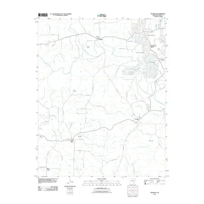
2011 Map of Franklin
USGS Topo · Published 2011About this map
Wiseman and the residential expansion of Horseshoe Bend define this 2011 survey of Izard County. The Strawberry River meanders across the landscape, joined by its tributaries Piney Fork and Town Branch. These waterways were the historical lifelines for early settlements like Franklin and Violet Hill. The northern section reveals a dense network of residential streets such as Fairway Dr and Mohawk Dr surrounding Bass Lake and Lodge Lake, indicating the area's development for recreation and housing. Genealogy researchers will find several well-documented burial sites including Nebo Cemetery and Old Liberty Cemetery. This map records the transition from rural farming communities to more structured residential developments while preserving the locations of early 20th-century civic markers like the Wiseman Post Office and Violet Hill Post Office.
Find a feature on this map
87 named features on this map. Tap any name to fly to it.
Don’t see what you’re looking for? This feature index may not catch every label — zoom into the map to look around manually.
Map Details
Editions of this 2011 Franklin Map
This is the sole edition of this map. No revisions or reprints were ever made.
Other maps of this area

1950 · Salem
USGS Topo · 1:62,500

1951 · Salem
USGS Topo · 1:62,500

1951 · Melbourne
USGS Topo · 1:62,500

1957 · Poplar Bluff
USGS Topo · 1:250,000

1959 · Poplar Bluff
USGS Topo · 1:250,000

1960 · Poplar Bluff
USGS Topo · 1:250,000
1962 · Sidney
USGS Topo · 1:24,000

1962 · Myron
USGS Topo · 1:24,000

1962 · Agnos
USGS Topo · 1:24,000
1976 · Salem SW
USGS Topo · 1:24,000