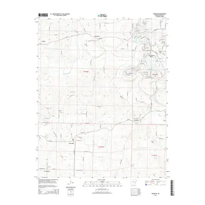
2014 Map of Franklin
USGS Topo · Published 2014About this map
Horseshoe Bend and the surrounding Ozark foothills are defined by the winding course of the Strawberry River and its numerous tributaries. This rural landscape in north-central Arkansas reveals a complex history of movement and settlement, evidenced by the presence of Trail Of Tears Ln and Military Rd near the community of Franklin. The map provides significant detail for genealogists, documenting a network of family and community burial grounds including Wiseman Cem, Nebo Cem, Oak Grove Cem, and Old Liberty Cem. To the northeast, the resort character of the region is visible in the planned residential streets and recreational waters of Lake Pioneer, Bass Lake, and Lodge Lake. This detailed topographical view captures the intersection of traditional agricultural settlements like Oxford, Wiseman, and Violet Hill with later 20th-century vacation developments.
Find a feature on this map
123 named features on this map. Tap any name to fly to it.
Don’t see what you’re looking for? This feature index may not catch every label — zoom into the map to look around manually.
Map Details
Editions of this 2014 Franklin Map
This is the sole edition of this map. No revisions or reprints were ever made.
Other maps of this area

1950 · Salem
USGS Topo · 1:62,500

1951 · Salem
USGS Topo · 1:62,500

1951 · Melbourne
USGS Topo · 1:62,500

1957 · Poplar Bluff
USGS Topo · 1:250,000

1959 · Poplar Bluff
USGS Topo · 1:250,000

1960 · Poplar Bluff
USGS Topo · 1:250,000
1962 · Sidney
USGS Topo · 1:24,000

1962 · Myron
USGS Topo · 1:24,000

1962 · Agnos
USGS Topo · 1:24,000
1976 · Salem SW
USGS Topo · 1:24,000