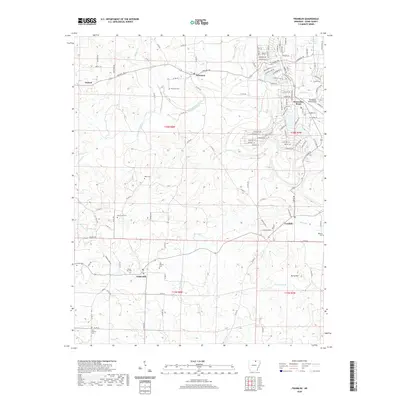
2020 Map of Franklin
USGS Topo · Published 2020About this map
Strawberry River meanders across this Izard County landscape, defining the rural character of a region where small towns like Oxford and Wiseman serve as local anchors. The map reveals a dense network of country roads and family burial grounds, including Wiseman Cem and Oak Grove Cem, reflecting deep-rooted settlement patterns. To the east, the modern development of Horseshoe Bend stands out with its intricate residential street names like Mockingbird Cir and Pioneer Lake Dr, clustered near Lodge Lake and the Horseshoe Bend Airport. This contrast between the established farming communities of Franklin and Violet Hill and the recreational growth near the river illustrates the evolving land use in the Arkansas Ozark foothills. Genealogists will find particular value in the numerous precisely located cemeteries, such as New Liberty Cem and Forest Cem, which mark the historical centers of these rural neighborhoods.
Find a feature on this map
125 named features on this map. Tap any name to fly to it.
Don’t see what you’re looking for? This feature index may not catch every label — zoom into the map to look around manually.
Map Details
Editions of this 2020 Franklin Map
This is the sole edition of this map. No revisions or reprints were ever made.
Other maps of this area

1950 · Salem
USGS Topo · 1:62,500

1951 · Salem
USGS Topo · 1:62,500

1951 · Melbourne
USGS Topo · 1:62,500

1957 · Poplar Bluff
USGS Topo · 1:250,000

1959 · Poplar Bluff
USGS Topo · 1:250,000

1960 · Poplar Bluff
USGS Topo · 1:250,000
1962 · Sidney
USGS Topo · 1:24,000

1962 · Myron
USGS Topo · 1:24,000

1962 · Agnos
USGS Topo · 1:24,000
1976 · Salem SW
USGS Topo · 1:24,000