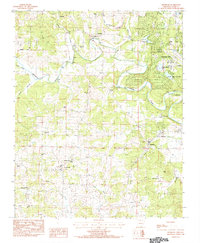
1984 Map of Franklin
USGS Topo · Published 1984About this map
Strawberry River meanders through the heart of this Izard County landscape, defining the character of North Central Arkansas in the early 1980s. The survey captures the recreational development of Horseshoe Bend, where Cedar Glade Lake, White Oak Lake, and a Golf Course sit alongside a local Airport. This growth contrasts with the established rural settlements of Wiseman, Franklin, and Violet Hill, where the economy is marked by scattered Quarry and Gravel Pit operations. Genealogists will find a wealth of data in the numerous burial grounds documented across the townships, including Wiseman Cem, Nebo Cem, and Old Liberty Cem. The drainage network is particularly detailed, tracing the Little Strawberry River, Bullpen Creek, and Piney Creek as they feed into the primary river valley, providing a clear record of the area's natural and man-made hydrology.
Find a feature on this map
35 named features on this map. Tap any name to fly to it.
Don’t see what you’re looking for? This feature index may not catch every label — zoom into the map to look around manually.
Map Details
Editions of this 1984 Franklin Map
This is the sole edition of this map. No revisions or reprints were ever made.
Other maps of this area

1950 · Salem
USGS Topo · 1:62,500

1951 · Salem
USGS Topo · 1:62,500

1951 · Melbourne
USGS Topo · 1:62,500

1957 · Poplar Bluff
USGS Topo · 1:250,000

1959 · Poplar Bluff
USGS Topo · 1:250,000

1960 · Poplar Bluff
USGS Topo · 1:250,000
1962 · Sidney
USGS Topo · 1:24,000

1962 · Myron
USGS Topo · 1:24,000

1962 · Agnos
USGS Topo · 1:24,000
1976 · Salem SW
USGS Topo · 1:24,000