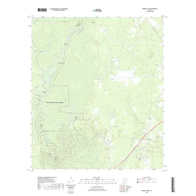
2019 Map of Franklin Lake
USGS Topo · Published 2019About this map
The Neches River forms a complex, winding boundary between Hardin and Jasper counties, defining a landscape of dramatic oxbows and swampy bottomlands. Much of this riparian wilderness is protected within the Big Thicket National Preserve, where the river's path creates distinct geographical features like Old Stove Bend, Cocklebur Bend, and Pearl River Bend. These hydrological shifts have left behind numerous secondary water bodies, including Franklin Lake, Johns Lake, and Bear Mans Lake, which serve as markers of the river's historical course. The surrounding terrain is characterized by low-lying marshes and bluffs such as Oak Bluff and Bear Mans Bluff. Evidence of regional timber and transport history is found in names like Old Tram Rd and Pool Stave Camp Lake, while a network of rural routes like Bunker Hill Rd provides access to the eastern uplands away from the river's flood-prone basin.
Find a feature on this map
67 named features on this map. Tap any name to fly to it.
Don’t see what you’re looking for? This feature index may not catch every label — zoom into the map to look around manually.
Map Details
Editions of this 2019 Franklin Lake Map
This is the sole edition of this map. No revisions or reprints were ever made.
Other maps of this area
1952 · Lake Charles
USGS Topo · 1:250,000
1954 · Lake Charles
USGS Topo · 1:250,000
1954 · Beaumont
USGS Topo · 1:250,000
1955 · Silsbee
USGS Topo · 1:62,500
1955 · Bessmay
USGS Topo · 1:62,500
1957 · Beaumont
USGS Topo · 1:250,000
1958 · Spurger
USGS Topo · 1:62,500
1958 · Kirbyville
USGS Topo · 1:62,500
1984 · Beaumont
USGS Topo · 1:250,000
1984 · Potato Patch Lake
USGS Topo · 1:24,000