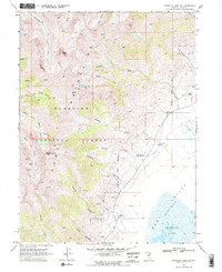
1969 Map of Franklin Lake NW
USGS Topo · Published 1972About this map
Ruby Mountains dominate this 1960s survey, showing a landscape defined by dramatic elevation changes and the high-desert transition into the Ruby Valley. The western half of the map is a network of sharp ridgelines and deep glacial carvings like Dawley Canyon and Jasper Canyon, while the eastern side flattens toward the shores of Franklin Lake and the expansive Alkali Flat.
Find a feature on this map
36 named features on this map. Tap any name to fly to it.
Don’t see what you’re looking for? This feature index may not catch every label — zoom into the map to look around manually.
Map Details
Editions of this 1969 Franklin Lake NW Map
3 editions found
Other maps of this area

1934 · Jiggs
USGS Topo · 1:125,000

1935 · Halleck
USGS Topo · 1:125,000

1937 · Jiggs
USGS Topo · 1:125,000

1955 · Elko
USGS Topo · 1:250,000

1958 · Elko
USGS Topo · 1:250,000

1959 · Jiggs
USGS Topo · 1:62,500

1962 · Elko
USGS Topo · 1:250,000

1962 · Lee
USGS Topo · 1:62,500

1962 · Lamoille
USGS Topo · 1:62,500

1965 · Elko
USGS Topo · 1:250,000