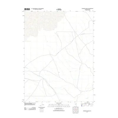
2012 Map of Franklin Lake SE
USGS Topo · Published 2012About this map
The arid high-desert floor of Elko County, Nevada, defines this corner of the Great Basin, where seasonal watercourses like Ruby Wash carve intermittent drainage patterns across the alluvial landscape. This 2012 survey shows a sparsely developed terrain primarily navigated by unpaved corridors such as Ruby Wash Rd and Medicine Spring Rd. These routes track the natural contours of the valley, providing essential access through an area where the hydrology is dominated by ephemeral streams like Cabin Run. The mapping reflects the enduring character of this remote rangeland, where human presence is marked by a minimal network of dirt roads that follow the ancient dry washes of the basin.
Find a feature on this map
4 named features on this map. Tap any name to fly to it.
Don’t see what you’re looking for? This feature index may not catch every label — zoom into the map to look around manually.
Map Details
Editions of this 2012 Franklin Lake SE Map
This is the sole edition of this map. No revisions or reprints were ever made.
Other maps of this area

1955 · Elko
USGS Topo · 1:250,000

1958 · Elko
USGS Topo · 1:250,000

1962 · Elko
USGS Topo · 1:250,000

1965 · Elko
USGS Topo · 1:250,000

1968 · Franklin Lake SE
USGS Topo · 1:24,000

1968 · Franklin Lake SW
USGS Topo · 1:24,000

1968 · Franklin Lake NE
USGS Topo · 1:24,000
1968 · Ruby Lake NW
USGS Topo · 1:24,000

1968 · Ruby Lake NE
USGS Topo · 1:24,000
1969 · Franklin Lake NW
USGS Topo · 1:24,000