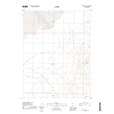
2018 Map of Franklin Lake SE
USGS Topo · Published 2018About this map
Ruby Valley dominates the northern reaches of this Elko County landscape, where the basin floor meets the rising slopes of the eastern high country. The terrain is defined by the seasonal movement of water through the Ruby Wash, which snakes across the western flats from its namesake roadway. Access through this portion of the Great Basin is centered on Ruby Wash Rd, a primary corridor that navigates the transition between the valley floor and the steep contours to the east. Farther south, the drainage of Cabin Run marks the descent toward the basin's edge. This 2018 survey illustrates a sparsely settled but strictly organized land system, revealing the precise boundaries of T28N R59E and surrounding townships that govern this open range.
Find a feature on this map
10 named features on this map. Tap any name to fly to it.
Don’t see what you’re looking for? This feature index may not catch every label — zoom into the map to look around manually.
Map Details
Editions of this 2018 Franklin Lake SE Map
This is the sole edition of this map. No revisions or reprints were ever made.
Other maps of this area

1955 · Elko
USGS Topo · 1:250,000

1958 · Elko
USGS Topo · 1:250,000

1962 · Elko
USGS Topo · 1:250,000

1965 · Elko
USGS Topo · 1:250,000

1968 · Franklin Lake SE
USGS Topo · 1:24,000

1968 · Franklin Lake SW
USGS Topo · 1:24,000

1968 · Franklin Lake NE
USGS Topo · 1:24,000
1968 · Ruby Lake NW
USGS Topo · 1:24,000

1968 · Ruby Lake NE
USGS Topo · 1:24,000
1969 · Franklin Lake NW
USGS Topo · 1:24,000