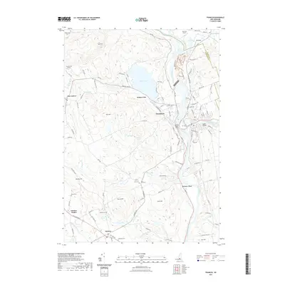
2021 Map of Franklin
USGS Topo · Published 2021About this map
The confluence of the Pemigewasset River and the Winnisquam Lake outlet forms the Merrimack River at the heart of Franklin. This 2021 survey shows a landscape where industrial infrastructure and historical burial grounds sit alongside significant water bodies like Webster Lake. Genealogists will find a wealth of data across numerous dedicated sites, including Shaw Corner Cem, Bog Road Cem, and Maplewood Cem. The transit history of the region is marked by the B & M RR corridor, which follows the river valleys through settlements such as Webster Place and Salisbury. The terrain transitions from the riverbanks to prominent heights like Pine Hill and Searles Hill, reflecting a classic New England pattern of valley-floor development and upland agriculture. Further west, the map details the rural character of Salisbury Heights and East Andover, where local aviation is noted at Tucker Farm Airport.
Find a feature on this map
130 named features on this map. Tap any name to fly to it.
Don’t see what you’re looking for? This feature index may not catch every label — zoom into the map to look around manually.
Map Details
Editions of this 2021 Franklin Map
This is the sole edition of this map. No revisions or reprints were ever made.
Other maps of this area

1925 · Holderness
USGS Topo · 1:62,500

1927 · Penacook
USGS Topo · 1:62,500

1927 · Holderness
USGS Topo · 1:62,500

1927 · Cardigan
USGS Topo · 1:62,500

1928 · Mount Kearsarge
USGS Topo · 1:62,500

1930 · Cardigan
USGS Topo · 1:62,500

1931 · Mount Kearsarge
USGS Topo · 1:62,500

1949 · Portland
USGS Topo · 1:250,000

1956 · Cardigan
USGS Topo · 1:62,500

1956 · Penacook
USGS Topo · 1:62,500