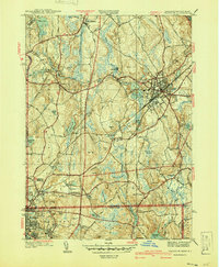
1940 Map of Franklin
USGS Topo · Published 1940About this map
Franklin and Bellingham anchor this 1940 survey of the Massachusetts and Rhode Island borderlands, where the Charles River winds through a landscape of drumlins and mill ponds. The industrial character of the era is evident in the rail lines of the New York New Haven and Hartford and the cluster of institutions such as Dean Academy and the local Infirmary. To the south, the map captures the transition into Woonsocket and the proximity of the Woonsocket Airport.
Find a feature on this map
63 named features on this map. Tap any name to fly to it.
Don’t see what you’re looking for? This feature index may not catch every label — zoom into the map to look around manually.
Map Details
Editions of this 1940 Franklin Map
2 editions found
Other maps of this area

1886 · Blackstone
USGS Topo · 1:62,500

1887 · Franklin
USGS Topo · 1:62,500

1887 · Providence
USGS Topo · 1:62,500

1889 · Providence
USGS Topo · 1:62,500

1889 · Blackstone
USGS Topo · 1:62,500

1889 · Franklin
USGS Topo · 1:62,500

1889 · Burrillville
USGS Topo · 1:62,500

1893 · Franklin
USGS Topo · 1:62,500

1893 · Blackstone
USGS Topo · 1:62,500

1894 · Burrillville
USGS Topo · 1:62,500