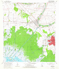
1963 Map of Franklin
USGS Topo · Published 1964About this map
The Bayou Teche defines the social and economic geography of St. Mary Parish in the early 1960s, serving as the historical spine for settlements like Baldwin and Franklin. The landscape is a complex intersection of traditional plantation agriculture, represented by Bodin Plantation and Lucy Plantation, and the industrial extraction of the Jeanerette Oil and Gas Field. Major transport corridors including the Southern Pacific and Missouri Pacific railroads parallel the bayou, facilitating the movement of sugar and oil. To the south, the terrain dissolves into the dense wetlands surrounding the Charenton Drainage and Navigation Canal and the Intracoastal Waterway, where a network of smaller streams like Choupique Bayou and Onion Bayou wind toward Mud Lake. Local community life is rooted in sites such as Willow Street High Sch and the Nazarene Ch.
Find a feature on this map
62 named features on this map. Tap any name to fly to it.
Don’t see what you’re looking for? This feature index may not catch every label — zoom into the map to look around manually.
Map Details
Editions of this 1963 Franklin Map
3 editions found
Other maps of this area

1937 · Bayou Sale
USGS Topo · 1:62,500

1937 · Jeanerette
USGS Topo · 1:62,500

1941 · Belle Isle
USGS Topo · 1:62,500

1945 · New Orleans
USGS Topo · 1:250,000

1948 · Foster
USGS Topo · 1:62,500

1954 · Jeanerette
USGS Topo · 1:62,500

1954 · Belle Isle
USGS Topo · 1:62,500

1957 · Bayou Sale
USGS Topo · 1:62,500

1959 · Foster
USGS Topo · 1:62,500

1963 · New Orleans
USGS Topo · 1:250,000