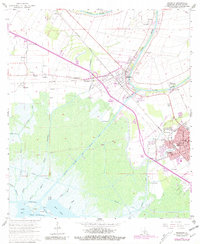
1963 Map of Franklin
USGS Topo · Published 1981About this map
Bayou Teche defines the settlement patterns of this St. Mary Parish landscape, where the historic town of Franklin and the village of Baldwin are situated along its winding banks. The region’s economic transition is visible through the coexistence of large estates like Bodin Plantation and Lucy Plantation alongside the Jeanerette Oil and Gas Field. Educational and social hubs serve the local population, including Willow Street High Sch, Hanson Sch, and the Nazarene Ch.
Find a feature on this map
62 named features on this map. Tap any name to fly to it.
Don’t see what you’re looking for? This feature index may not catch every label — zoom into the map to look around manually.
Map Details
Editions of this 1963 Franklin Map
3 editions found
Other maps of this area

1937 · Bayou Sale
USGS Topo · 1:62,500

1937 · Jeanerette
USGS Topo · 1:62,500

1941 · Belle Isle
USGS Topo · 1:62,500

1945 · New Orleans
USGS Topo · 1:250,000

1948 · Foster
USGS Topo · 1:62,500

1954 · Jeanerette
USGS Topo · 1:62,500

1954 · Belle Isle
USGS Topo · 1:62,500

1957 · Bayou Sale
USGS Topo · 1:62,500

1959 · Foster
USGS Topo · 1:62,500

1963 · New Orleans
USGS Topo · 1:250,000