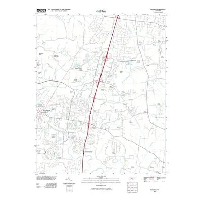
2010 Map of Franklin
USGS Topo · Published 2010About this map
Franklin and its surrounding countryside are captured here just as the suburban expansion of the early 21st century met the deep-rooted landmarks of Williamson County. The landscape is a dense network of family history, marked by dozens of burial grounds ranging from the Confederate Cemetery and McGavock Cemetery near the city center to smaller family plots like the Brooks Cemetery and Hodge Cemetery scattered across the hills. The terrain is defined by prominent elevations such as Ropers Knob and Strambler Knob, while the Harpeth River and its many branches, including North Ewingville Creek, snake through the valleys.
Find a feature on this map
133 named features on this map. Tap any name to fly to it.
Don’t see what you’re looking for? This feature index may not catch every label — zoom into the map to look around manually.
Map Details
Editions of this 2010 Franklin Map
This is the sole edition of this map. No revisions or reprints were ever made.
Other maps of this area

1903 · Nashville
USGS Topo · 1:125,000

1909 · Franklin
USGS Topo · 1:62,500
1932 · Hermitage
USGS Topo · 1:62,500
1932 · Nashville
USGS Topo · 1:62,500
1936 · Spring Hill
USGS Topo · 1:24,000
1936 · Bethesda
USGS Topo · 1:24,000

1942 · Lebanon
USGS Topo · 1:100,000
1946 · Leipers Fork
USGS Topo · 1:24,000
1946 · Bethesda
USGS Topo · 1:24,000
1946 · Spring Hill
USGS Topo · 1:24,000