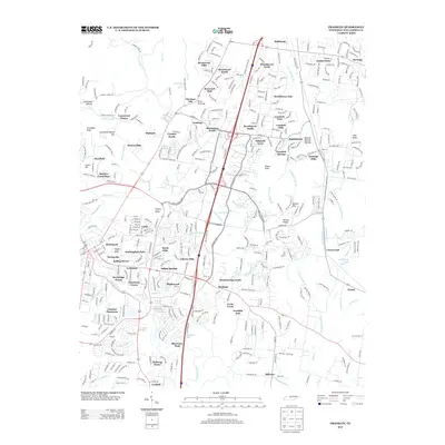
2013 Map of Franklin
USGS Topo · Published 2013About this map
Boiling Springs Mounds sits near the eastern edge of this landscape, marking a site of deep pre-colonial significance amidst the modern suburban expansion of Williamson County. The corridor is defined by the winding course of the Harpeth River and its numerous tributaries, including Spencer Cr and Ewingville Cr, which carve through a terrain punctuated by prominent high points like Ropers Knob and Sliders Knob. This 2013 survey illustrates the dense residential character of the region, where established neighborhoods such as Brentwood Hills, Brenthaven North, and Carriage Hills are woven between historical landmarks like Boxwood Hall. The hydrology of the area is particularly complex, featuring Whitehearst Cave Spring and smaller drainages like Hill Cemetery Br and Cotton Gin Br, reflecting a land that was once heavily shaped by its water sources and springs before the contemporary road network of I-65 and Us-31 transformed local connectivity.
Find a feature on this map
111 named features on this map. Tap any name to fly to it.
Don’t see what you’re looking for? This feature index may not catch every label — zoom into the map to look around manually.
Map Details
Editions of this 2013 Franklin Map
This is the sole edition of this map. No revisions or reprints were ever made.
Other maps of this area

1903 · Nashville
USGS Topo · 1:125,000

1909 · Franklin
USGS Topo · 1:62,500

1932 · Hermitage
USGS Topo · 1:62,500

1932 · Nashville
USGS Topo · 1:62,500

1936 · Spring Hill
USGS Topo · 1:24,000

1936 · Bethesda
USGS Topo · 1:24,000

1942 · Lebanon
USGS Topo · 1:100,000

1946 · Leipers Fork
USGS Topo · 1:24,000

1946 · Bethesda
USGS Topo · 1:24,000
1946 · Spring Hill
USGS Topo · 1:24,000