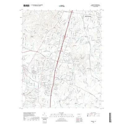
2019 Map of Franklin
USGS Topo · Published 2019About this map
Franklin and the southern reaches of Brentwood are captured here during a period of significant suburban expansion in Williamson County. This topographic study reveals a landscape defined by its historic memory, where modern developments like the Mack C Hatcher Memorial Pkwy intersect with ancestral sites such as the Boiling Springs Mounds and numerous family burying grounds. The Harpeth River and its many tributaries, including Liberty Cr and Spencer Cr, thread through the terrain, anchoring older communities like Ewingville and Clovercroft. Local heritage is deeply embedded in the land, evidenced by the concentration of sites like the Confederate Cem and McGavock Cem. To the east and south, the map documents smaller crossroads and locales such as Trinity, Millview, and the curiously named Mudsink, providing a detailed view of the county's transition from rural farmsteads to a primary residential hub.
Find a feature on this map
163 named features on this map. Tap any name to fly to it.
Don’t see what you’re looking for? This feature index may not catch every label — zoom into the map to look around manually.
Map Details
Editions of this 2019 Franklin Map
This is the sole edition of this map. No revisions or reprints were ever made.
Other maps of this area

1903 · Nashville
USGS Topo · 1:125,000

1909 · Franklin
USGS Topo · 1:62,500

1932 · Hermitage
USGS Topo · 1:62,500

1932 · Nashville
USGS Topo · 1:62,500

1936 · Spring Hill
USGS Topo · 1:24,000

1936 · Bethesda
USGS Topo · 1:24,000

1942 · Lebanon
USGS Topo · 1:100,000

1946 · Leipers Fork
USGS Topo · 1:24,000

1946 · Bethesda
USGS Topo · 1:24,000
1946 · Spring Hill
USGS Topo · 1:24,000