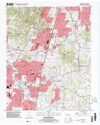
1997 Map of Franklin
USGS Topo · Published 2002About this map
The Harpeth River carves a winding path through this portion of Williamson County, where the transition from suburban expansion to traditional farmland is visible in the late 1990s. Surrounding the city of Franklin, a dense concentration of family and community burial sites such as McConnico Cem, Nolen-Flynn Cem, and Halfacre Cem highlights the area's deep genealogical roots. The landscape is marked by distinctive topographical features like Ropers Knob and Strambler Knob, while the northern reaches near Brentwood show the growth of residential developments such as Mooreland Estates and Brentwood Hills. Notable landmarks including the Confederate Cem and McGavock Cem sit near the river's edge, reflecting the historical significance of the terrain during the Civil War era. Transport networks are anchored by the Road Interchange 65 and the older routes of Concord Road and Murfreesboro Road.
Find a feature on this map
91 named features on this map. Tap any name to fly to it.
Don’t see what you’re looking for? This feature index may not catch every label — zoom into the map to look around manually.
Map Details
Editions of this 1997 Franklin Map
This is the sole edition of this map. No revisions or reprints were ever made.
Other maps of this area

1903 · Nashville
USGS Topo · 1:125,000

1909 · Franklin
USGS Topo · 1:62,500

1932 · Hermitage
USGS Topo · 1:62,500

1932 · Nashville
USGS Topo · 1:62,500

1936 · Spring Hill
USGS Topo · 1:24,000

1936 · Bethesda
USGS Topo · 1:24,000

1942 · Lebanon
USGS Topo · 1:100,000

1946 · Leipers Fork
USGS Topo · 1:24,000

1946 · Bethesda
USGS Topo · 1:24,000
1946 · Spring Hill
USGS Topo · 1:24,000
Featured Places
- Franklin, TN
- Brentwood, TN
- Jamestown, Brentwood
- Crockett Cove, Brentwood
- Concord Country Estates, Brentwood