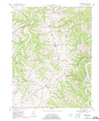
1954 Map of Franklinton
USGS Topo · Published 1987About this map
Franklinton and the surrounding rural communities of Henry County are captured here in a transition period, with original 1954 topography updated via 1984 aerial photography. The landscape is defined by the winding course of Drennon Creek and the southern flow of Sixmile Creek, creating a network of ridges and hollows such as Happy Ridges and Foot Hollow. This area shows a settlement pattern of small crossroads and community centers like Bethlehem, Slabtown, and Defville, which served the local agricultural population.
Find a feature on this map
29 named features on this map. Tap any name to fly to it.
Don’t see what you’re looking for? This feature index may not catch every label — zoom into the map to look around manually.
Map Details
Editions of this 1954 Franklinton Map
2 editions found
Other maps of this area

1906 · Lockport
USGS Topo · 1:48,000

1908 · Lockport
USGS Topo · 1:62,500

1928 · New Castle
USGS Topo · 1:48,000

1932 · New Castle
USGS Topo · 1:62,500

1950 · New Liberty
USGS Topo · 1:24,000

1952 · Worthville
USGS Topo · 1:24,000

1952 · Campbellsburg
USGS Topo · 1:24,000

1953 · Gratz
USGS Topo · 1:24,000

1953 · Polsgrove
USGS Topo · 1:24,000
1954 · New Castle
USGS Topo · 1:24,000